Drive on any motorway or A road, and you’ll see small blue signs by the side of the carriageway every 500 metres or so. These are driver location signs, and they’re used by breakdown teams and the emergency services to find stranded vehicles and accidents on England’s trunk roads.
In this guide, we run through why location signs were first introduced, how they work, and what they tell us. We’ll answer these frequently asked questions:
- Why Were Driver Location Signs First Introduced?
- Where Will You See Driver Location Signs and What Do They Look Like?
- What Information do Driver Location Signs Provide?
- How to Read Driver Location Signs – What do the Letters and Numbers Mean?
Why Were Driver Location Signs First Introduced?
Before mobile phones, drivers had to use emergency phones by the side of the road to call their breakdown provider or notify the emergency services of an accident. That meant their location could be easily traced, whereas with a mobile, the driver could be anywhere and, in some circumstances, it would be impossible to give an accurate description of their location.
In 2003, location signs were introduced to tackle the problem of drivers calling emergency services and breakdown providers from a mobile to report an incident without actually knowing where they were. Instead of deciphering a sketchy description, these signs give authorities clear-cut information to help pinpoint a vehicle or incident, removing the guesswork from finding a stranded vehicle or accident.
Even if a driver doesn’t know how to read a location marker, they can simply pass on the information to the relevant party who will know their location by the figures provided.
Where Will You See Driver Location Signs and What Do They Look Like?
Driver location signs are small and blue, with three lines of text made up of numbers and letters in a yellow font. They’re found on all motorways and slip roads in England, as well as some major A roads. Since 2009, location markers are no longer available in Scotland, Wales and Northern Ireland. To prevent drivers having to walk far on the side of the carriageway to find a sign, markers are placed at intervals of 500m and are readable from a considerable distance.

What Information do Driver Location Signs Provide?
Location markers make it easy for breakdown crews and the emergency services to reach stranded motorists and incidents, offering a pinpoint location of where the motorist is calling from to the nearest 500 metres.
They provide the following information to make it easy to find a person’s location:
- The road the driver is on, e.g. M6
- The direction the driver is travelling, e.g. A refers to one side of the carriageway and B the other
- How far the driver is from a given location – usually the ‘start’ of the road
How to Read Driver Location Signs – What do the Letters and Numbers Mean?
Each row on a driver location sign corresponds to the information listed above, giving a complete breakdown of where on a motorway you are.
First line = The name of the road
e.g. M62, A63, M602
Second line = The direction of travel
This is always A or B. ‘A’ usually means northbound or ‘away’ from London, and is the side of the carriageway where the numbers count up. ‘B’ means southbound or ‘back’ to London, and corresponds to the side of the carriageway where the numbers count down. You may also see other letters such as J and K, which are used on slip roads.
Third line = Distance from the designated starting point of the road
This number gives your exact location in kilometres from the starting point of the road (as designated by the Highways Agency). As the signs are found every 500m, the numbers count up or down in intervals of .5, so you may see a figure such as 307.5 or 307.0. This is perhaps the most important figure on the marker, as it pinpoints your location on a road that could span over 200 miles.
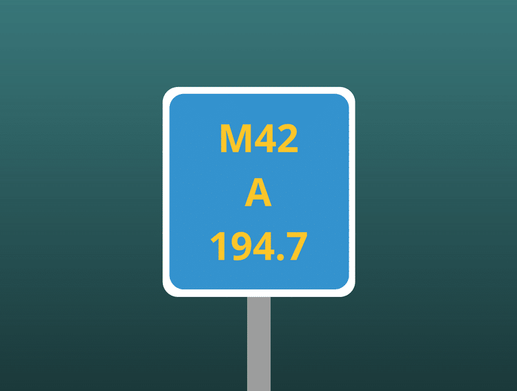
Example:
M42 = Motorway running between Worcestershire and Leicestershire in the West Midlands.
A = Northbound side, travelling away from London towards Leicestershire.
34.5 = 34.5 kilometres from the start of the motorway in Bromsgrove, Worcestershire.

Tips for Using Driver Location Signs
If you suffer an unexpected breakdown or witness an incident, here are some tips for safely using a driver location sign to give the location to your breakdown provider or the emergency services.
- If you suffer a breakdown on a motorway but can’t read the nearest location marker, don’t walk to it and put yourself at risk. Instead, use Google Street View on your smartphone to read the nearest marker to your GPS location.
- When you witness an incident, make sure you use a hands-free device when alerting emergency services of the location marker information, or else find somewhere safe to stop.
- On a motorway, only ever give the marker location on your side of the carriageway.
- Try to keep tabs on at least the bottom number of passing location markers, as the top two are generally much easier to remember. This will give you a general idea of what information to give to authorities after an incident, even if you aren’t close enough to read the nearest marker.
- Using an emergency telephone is still the easiest and cheapest way to call for assistance on the motorway, so use them if there’s one nearby.
Holts have a range of DIY emergency car maintenance products that are designed to get you moving again after a roadside breakdown or flat tyre. To find out more and view our complete product range, visit the homepage.